Manyoshu Volume 14, Collection of Songs 3543: The daughter says that the relationship will gradually deepen, just as the bank in Tsuru, which is overgrown with grass, will gradually be completed in the new room where virginity becomes a woman, but she still cannot sleep together: Marriage fulfillment (subject of application); Tsurukawa - extended life and longevity - Nanahiko porridge: Engishiki; Sagami Fukuchi - Japanese name Ruijusho - Imperial Prince Kinshi, Emperor Daigo, Emperor Saga, Emperor Kanmu (Yamabe) - Nagaokakyo, Heiankyo
The area within Tsuru County has been separated into Minami and Kitatsuru counties, but this has been the case since 1878 when Minami and Kitatsuru counties were established under the Nerima Station Town, Town and Village Organization Act. Before that, Tsuru County was established as a unified region. It is recognized in "Teikishiki" and "Wamyo Ruijusho" that it was placed as a local organization in Kai Province under the Ritsuryo system, along with Yamanashi, Yashiro, and Koma. "Engishiki" is a compilation of the Shiki, which was the detailed enforcement regulations of the Ritsuryo Kaku, which Fujiwara Tokihira and Tadahira began compiling in 905 at the order of Emperor Daigo and completed in 927. At the top of the civil section, the name of the nation, its grade (large, upper, middle, lower), the name of the county under its jurisdiction, and classification based on distance from the capital (near country, China, distant country) are listed.
【Product name】
Kanno Nakate
Prunus salicina Lindl.
The name “幸峰” at the time of filing was. Later, it was named after the breeder Mr. Yukio KANNO.
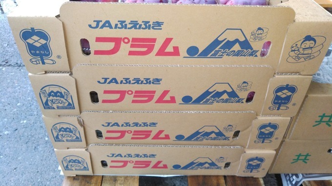
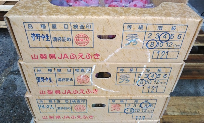
In Yamanashi prefecture, there is a risk of gusts and hail until the morning of July 6, 2022, and farmers are busy responding. "I want to deliver the things that have been stolen to consumers." Momo farmers are busy preparing for heavy rain. Farmers took measures to prepare for the heavy rain on the 6th, and at the peach farm in Ichinomiya Town , Fuefuki City, a support of about 2 m was attached to the branch so that the lovely fruits just before harvest would not fall in the wind, and the wind and rain hit the peach directly. I'm cutting down the stretched branches so that I don't. “Fuefuki City, Yamanashi Prefecture”, Located slightly east of the central part of the Kofu basin. Collecting water systems flowing from the mountainous hills in the north, east and south of the basin: The Fuefuki River flows southwest through the central part of the basin. 日川, 金川, 浅川, 境川 etc. The alluvial fan and the alluvial plain at the bottom of the basin spread out.In addition, agricultural land mainly composed of fruit trees is distributed from the foot of the mountain to the flat land. Behind it is misaka mountains, there are villages scattered along the Ashigawa River, which flows from east to west in the mountains. In this way, centering on the flat land that extends along the Fuefuki River: Area with relatively cohesive terrain sandwiched between north and south hills and mountains range. The soil is fertile and well drained: Excellent for fruit tree cultivation due to long hours of daylight and large temperature difference between day and night. Ministry of agriculture, forestry and fisheries Fruit tree production shipping statistics: Cultivation area, yield and shipment of peach / grape every year-All are the best among the cities, towns and villages in Japan. Honoring the feats of our predecessors who have led the historic cultivation of fruit trees in Japan: We pledge to protect and further develop the wonderful fruit villages that we can be proud of throughout the country. Peach and Grape, declaration of Japan's No. 1 Township in October 2005. On April 10, 2013, we will declare Japan's number one paradise on earth. 文化財他 : 佐久神社本殿 : 県指定, 石和, 八田家書院 / 八田御朱印公園 : 県指定, 石和, 絹本著色仏涅槃図 : 国指定重, 石和, 木造大物主神立像, 国指定重 : 御坂, 板絵著色三十六歌仙図 : 県指定, 御坂, 美和神社の太々神楽 : 県指定, 御坂, 白糸威褄取鎧〈残欠〉: 県指定重, 御坂, 朱礼紅糸素懸威胴丸佩楯付〈一領〉: 県指定, 御坂, 木造吉祥天坐像と二天像 : 国指定重, 御坂, 木造香王観音像 : 県指定, 御坂, 木造他阿真教上人坐像 : 国指定重, 御坂, 称願寺の桜 : 県指定, 御坂, 御坂隧道 : 国登録, 御坂, 檜峯神社コノハズク確認の地 : 県指定, 御坂, 姥塚 : 県指定, 御坂, 下黒駒の大ヒイラギ : 県指定, 御坂, 渦文深鉢 : 県指定, 御坂, 美和神社, 御坂, 福光園寺, 御坂, 称願寺, 御坂, 檜峯神社, 御坂, 花鳥山一本杉 : 市指定, 御坂 / 八代, 星石 : 市指定, 御坂, 浅間神社摂社山宮神社本殿 : 国指定, 一宮, 慈眼寺本堂 : 国指定, 一宮, 慈眼寺庫裏 : 国指定, 一宮, 慈眼寺鐘楼門 : 国指定, 一宮, 紺紙金泥般若心経 付武田晴信自筆奉納包 : 国指定, 一宮, 甲斐国分寺跡 : 国指定史跡, 一宮, 甲斐国分尼寺跡 : 国指定史跡, 一宮, 木造十一面観音菩薩立像 : 県指定, 一宮, 石造地蔵菩薩坐像 : 県指定, 一宮, 超願寺文書 : 県指定, 一宮, 広厳院文書 : 県指定, 一宮, 梵字法帖 : 県指定, 一宮, 銅鐘 : 県指定, 一宮, 太刀 銘国次 : 県指定, 一宮, 古常滑大甕 / 支那青磁碗 / 同染付碗皿 / 黄瀬戸皿, 県指定, 一宮, 古瀬戸瓶 古常滑大甕 : 県指定, 一宮, 太刀 : 銘一徳斉助則 : 県指定, 一宮, 刺繍法華経 : 県指定, 一宮, 刀剣 : 銘広重 附衛府太刀拵 : 県指定, 一宮, 紙本著色星曼荼羅 : 県指定, 一宮, 経塚古墳 : 県指定, 一宮, 夫婦梅 : 県指定, 一宮, ルミエール旧地下発酵槽 : 国登録, 一宮, 土偶 (釈迦堂遺跡出土品) : 国指定重, 一宮, 一宮浅間神社, 一宮, 浅間神社摂社山宮神社の夫婦杉 : 市指定, 一宮, 岡の式三番叟 : 県指定, 八代, 菱雲文帯半円方形四乳鏡 : 県指定, 八代, 岡 / 銚子塚古墳 : 県指定, 八代, 御崎古墳出土品362点 : 県指定, 八代, 竜塚古墳 :県指定, 八代, 木造如来形坐像及び塑像仏像残欠 : 県指定, 八代, 木造十二神将立像 : 県指定, 八代, 絹本著色熊野曼荼羅 附桐箱 : 県指定, 八代, 荒神堂のケヤキ : 市指定, 八代, 木造虚空蔵菩薩坐像 : 県指定, 境川, 版本大般若経 : 県指定, 境川, 桑原家文書 : 県指定, 境川, 智光寺のカヤ : 県指定, 境川, 宗源寺のヒダリマキカヤ : 県指定, 境川, 地蔵堂塚古墳出土蕨手刀 : 県指定, 境川, 藤垈の滝, 境川, 山梨岡神社本殿 : 国指定, 春日居, 山梨岡神社太々神楽 : 県指定, 春日居, 木造五大明王像 : 県指定, 春日居, 木造立川不動明王坐像 : 県指定, 春日居, 寺本廃寺跡 : 県指定, 春日居. 平成17年11月1日に, 塩山市, 東山梨郡勝沼町, 大和村と合併し,「甲斐国」の別称 “Koshu City”,(Concerning municipalities which changed characters for names and adopted old provincial names virtually, there are Mutsu City(青森県), Iwaki City(福島県), Sanuki City(香川県), Oushu City(岩手県), and Koshu City.)になる. 甲府盆地の東側に位置し, 富士山, 南アルプス(The South Alps cover an area of over 300,000 hectares across Yamanashi, Nagano and Shizuoka Prefectures.), 八ヶ岳(谷戸城跡:史跡名勝天然記念物; 北巨摩郡大泉村(現: 北杜市): 指定年月日, 1993. 11/29, Located in the southern foothill of Yatsugatake, Henmiso had Henmi-no-maki, a livestock grazing land for ancient officials, spreading in the area, and Kiyomitsu settled in present Seikoji Temple area (Nagasaka Town , Hokuto City) (alleged otherwise to be located at Wakamiko, Sudama Town , Hokuto City) and built Yato Castle (Oizumi Village, Hokuto City, Yamanashi Prefecture) as tsume-no-shiro, a retreat and backup castle.)などの緑豊かな山々に, 囲まれている「フルーツ」の栽培適地である. “武田信玄” 公の菩提寺として, 名高い「恵林寺(His family temple was the Erin-ji Temple in Koshu City, Yamanashi Prefecture.)」, 子の「勝頼(四郎)」公, の菩提寺である「景徳院」, 風林火山(During the period of the Northern and Southern Courts, which was about 200 years earlier than the period of Shingen, the banner was used by Akiie KITABATAKE as a Jinki (the flag for a camp) containing the emblem, Fu-Rin-Ka-Zan. Akiie KITABATAKE used this emblem on his flag and fought against Takauji ASHIKAGA until Takauji at one time was driven to take his own life in an instant. Shingen TAKEDA was not the first to use the battle flag of Fu-Rin-Ka-Zan. )で, お馴染みの「孫子の旗; 兵法(The Art of War (military text by Sun Tzu,512 BCE): Dou XIN said, "the Art of War by Tzu SUN tells us that an obstinate attitude leads a small army to being captured by a large army. If the small army fiercely fights against the large army without considering the deference of their fighting strength, it will end up being captured. It is not a perfect plan to force tired soldiers to fight against the enemy that is increasing in number. We should withdraw." The art of warfare of Sonshi (Chinese books about tactics) in the ancient China is famous in Japan, too. Hatajirushi: A flag of Sonshi (also known as a flag of Fu-Rin-Ka-Zan which literally means "Wind, Forest, Fire, and Mountain," which was the motto of the feudal lord Shingen TAKEDA, quoted from Sonshi (Chinese books about tactics), meaning "swift as the wind, quiet as a wood, fierce as fire, and immovable as a mountain."), a flag of Suwa Myojin (The Suwa Deity) )」や, 日本最古の「日の丸御旗(flag with a red circle on a white background)」を所蔵する「雲峰寺(臨済宗妙心寺派 裂石山,(関連; 影武者: 黒澤明監督, 大菩薩峠: 中里介山(弥之助))」, 武田家代々の家督の印とされる国宝「楯無鎧」を預かる「菅田天神社」(Tatenashi (no shield) (Kanda-tenjinja Shrine) – handed down from the Takeda clan.), 武田家と縁の深い社寺仏閣が数多く存在する. Katsunuma district,National / prefecture designated cultural property(甲州市勝沼地区)“国宝” 大善寺本堂附厨子 / 大善寺「彫刻重要文化財」, 木造薬師如来及両脇侍像,木造十二神将立像, “史跡” 勝沼(武田信虎, 弟君2代(信友))氏館跡, 勝沼町, 勝沼字御所 / 甲州市「名勝県指定文化財」, 大善寺庭園 / 大善寺三光寺庭園 / 三光寺 “記念物”, 萬福寺のムクノキ / 萬福寺 “建造物” 旧宮崎醸造所 / メルシャン大善寺山門 / 大善寺 “彫刻” 大善寺役行者椅像 / 大善寺大善寺日光月光菩薩立像, ”工芸品” 大善寺鰐口, “古文書” 大善寺文書,「工作物登録文化財」葡萄酒貯蔵庫, 堰堤, 祝橋. Temple of origin of Japanese grape cultivation - A “Bhaisajyaguru (buddha able to cure all ills)” holding a rare grape is enshrined. “Kofu City”, It is located almost in the center of the prefecture. The city area is 23.1 km east-west, 41.6 km north-south, and the area is 212.47 km2. In the northernmost mountainous area, Mt. Hachiman, Mt. Kinpu, and Mt. Asahi are lined up from east to west. Mt. Ou and Mt. Shakkagatake are in the south. The city area is located in the center of the Kofu basin. It is generally flat, but tends to slope high to the north and low to the south. From the city, you can see Mt. yatsugatake to the north, Mt. fuji to the south, and the Southern Alps mountain range to the west. Arakawa flows from the main peak of Chichibu-Tama-Kai National Park. Certified as "Heisei Best Water 100's" in 2008: Mitakeshosenkyo boasts one of the best canyon beauty in Japan. A land pattern blessed with abundant nature such as the Ashigawa Valley. City tree: subgen. Cyclobalanopsis or Cyclobalanopsis: It is an evergreen tree of the family Fagaceae and grows naturally in Kofu. The material is very hard, and the tree shape grows magnificently toward the heavens. The tree shape that extends toward the sky symbolizes the future of the city: Designated in August 1971. Flowers: Dianthus: It is widely distributed all over the world and is loved as a flower that is very easy to grow. The strength and beauty of blooming withstanding the heat and cold are suitable for symbolizing Kofu: Designated in January 1958. Bird: Alcedo atthis Linnaeus, 1758: It is known as a resident bird (a wild bird that does not leave the land born until death) that lives on the banks of rivers and on the water's edge. It is also called a "flying jewel" because of the beauty of its back wings. It is most suitable for "Kofu, the city of jewels": Designated in August 1984. Nine declarations: Road safety city; December 9, 1958, Pollution-free city; July 8, 1971, Nuclear Weapons Abolition Peace City; July 2, 1982, Greening promotion city; March 13, 1986, Clear creative city; July 6, 1990, Volunteer city; December 9, 1994, Lifelong Learning city; June 12, 1998, Gender equality city; June 20, 2013, Healthy city; September 19, 1st year of Reiwa. History: People started living at the foot of the mountain in the Paleolithic era about 27,000 years ago. In the Yayoi period, when rice farming began, villages were set up in lowlands and the development of the bottom of the basin began. Construction of burial mounds began in the city area in the middle of the 4th century. The existence of Kannduka, which boasts a huge horizontal hole type stone chamber, indicates the rise of political power with great economic power. At the end of the Heian period, Nobuyoshi Takeda led Kai Genji and solidified Kai's rule. His sons Tadayori Ichijyo and Kanenobu Itagaki set up a mansion in the city area. He also participated in the raising of Minamoto no Yoritomo and contributed to the establishment of the Kamakura Shogunate. It was Nobutura that laid the foundation for Mr. Takeda to fly as a warring lord. Nobutora, who took over the role of guardian of Kai at the age of 14, overwhelmed the rebellious influential landlord.Built a residence in Tsutsujigasaki(Currently, Takeda Shrine is enshrined in the castle.)and started construction of a castle town. I hear that is the beginning of Kai's Fuchu "Kofu". With the expansion of power, Kofu has developed into one of the largest castle towns in the eastern country. Shingen: Construction of a large river embankment to protect the kofu basin from flood disasters. Creation of a monetary system using koshu money. Enactment of law for territorial governance: laws established by daimyo applicable only in their own domain (during the Warring States period); Koshu Hatto no Shidai (the Laws of the Province of Kai) of the Takeda clan laid down that 'both parties to a quarrel leading to violence were to be executed regardless of their reasons; however, those who were involved in quarrels, but who kept their patience were not to be punished.' In Koshu Hatto no Shidai (the Laws of the Province of Kai), it was defined that Yoriko would bring a suit to Yorioya regardless of its content. The castle town was expanded by relocating Shinano Zenkoji Temple to Kofu to enrich Kai Province. I hear that the castle town of Kofu prospered most throughout the early modern period during the time of Mr. Yanagisawa. It was limited to daimyo feudal lord in hereditary vassalage to the Tokugawa house, but Yoshiyasu, an aide to General Tsunayoshi, accepted Kai. The maintenance of the castle town was promoted for two generations of father and son. After that, it became the direct control of the Shogunate, and Kofu Castle was under the control of the duty, and the end of the Tokugawa shogunate was reached. The city system was enforced in 1889. It is the 34th in Japan and second only to Yokohama, Mito and Tokyo in the Kanto region. Kofu air raid in July 1945 scorched 74% of the city area. The remnants of the good old days of Kofu have been lost. However, immediately after the end of the war, the war damage reconstruction station(War Damage Reconstruction Board: War-damaged area reconstruction plan basic policy; Cabinet decision on December 30th.)was set up, and the citizens came together to stand up for the reconstruction of their hometown with a high hammer; War Damage Reconstruction Institute. What about Japan today? “Chuo City”, Located in the south central part of the prefecture. The east is adjacent to Kofu City across the Kamata River. To the north is JR Minobu Line, Showa Town with Showa Bypass as the boundary: West is in the city of minami Alps across the Kamanashi River, the south is adjacent to Ichikawamisato Town. An area consisting of an alluvial plain area formed by the Kamanashi River and Misaka mountains. It has two geographical characteristics, and between the two jurisdictions are separated by the Fuefuki River. The flat part is Tamaho and Tatomi: Located between the Fuefuki River and the Kamanashi River. It is famous as an area spread over abundant mountainous areas. The area of the city is 31.69 km2. Land use goes back to the past in 2003: Residential land 19.4%, agricultural land 36.5%, forests 16.4%, others 27.7; The proportion of agricultural land was high. Special products are peach, asparagus, and maize: Alcoholic spirit distilled from corn, 恵 / Silk products “Silk Flower” “First Silk”, Grape, Wine. B-1 grand prix-Exhibited food with Local delicacy; Bloom of youth tomato noodles. Holding a sweet corn marathon, etc. Many residents love their hometown, which has a long history and the blessings of nature. 木造薬師如来坐像 (富田山 歓盛院; 曹洞宗) : 国指定重要文化財, 下三條, 木造釈迦如来坐像 : 市指定文化財.木造聖観音立像 (豊田山 永源寺; 華厳宗, 真言宗, 現: 曹洞宗, 加藤梵玄 公; Fujiwara clan) : 国指定重要文化財, 下河東. 浅利義遠(与一)公; Son of the founder of “Henmi style archery”. Kai-Genji (Minamoto clan): 三与一, Battle of Dannoura. The soil in Fuefuki City’s fertile, has good drainage, has long sunshine hours, and has a large temperature difference between day and night. Yamanashi's complex fruit tree system adapted to the basin: Yamanashi Prefecture Kyotou area ("Fuefuki" city, Yamanashi city, Koshu city March 2017, Food and Agriculture Organization: FAO (established in 1945) A United Nations specialized agency in the fields of food and agriculture, forestry and fisheries, the secretariat is Italy, Rome. Membership is 194 countries. (Japan joined in 1951), 2 Associate Member States and the European Union (EU). World Economy For the purpose of developing and freeing humankind from hunger, formulating international rules in the field of agriculture, forestry and fisheries, collecting information on world food and agriculture, forestry and fishery products, transmitting, analyzing, preparing statistical data, and providing a forum for international consultation. Provision, technical advice to developing countries, technical cooperation, etc.): Globally Important Agricultural Heritage Systems; Ministry of Agriculture, Forestry and Fisheries(Japan)): 日本において, 重要かつ伝統的な農林水産業を営む地域を, 農林水産大臣が認定する制度. 峽東地域; With more than 300 varieties, it serves as a storehouse for Japanese fruit varieties. 世界農業遺産認定に向けて(2019年(令和元年10月8日)): Globally Important Agricultural Heritage Systems; FAO, 2002: Biodiversity(果樹園に自生する植物を利用した草生栽培は, 土壌の流亡防止や有機物の補給だけでなく, 多様な生物の生息に, 大きく貢献) and Sustainable agriculture(There is an urgent need to advance research and development efforts to respond to the improvement of the food self-sufficiency rate): geographical indications: GIマーク(地理的表示)など. やまなし「エコファーマー; Environmentally friendly farmer (as recognized by law)」とは,「持続性の高い農業生産方式の導入の促進に関する法律」であり, 1999年(平成11年)7月28日法律第110号)「持続農業法」に制定, 同年10月25日に施行された.たい肥等による土づくりと, 化学肥料や化学合成農薬の低減を一体的に行う, 農業生産方式の導入計画について, 山梨県(道,(県),府)知事の認定を受けた農業者である.「エコファーマーになる為に必要な技術認定」「土づくりに関する技術」(たい肥の施用, 緑肥作物の栽培等)「化学肥料低減技術」(有機質肥料の利用, 局所施肥等)「化学農薬低減技術」(生物農薬の利用, 機械除草など)以下の3区分に該当する技術を一つずつ(以上)導入する必要がある. ‘Ministry of Agriculture, Forestry and Fisheries From Variety Registration’: Application No. 4936 Date of Application 1991/12/19, Date of publication of application-Registration number 4542: 登録年月日, 1995/06/13, 育成者権の存続期間18年: Breeders' rights extinction date 2013/06/14 * Period expired. 品種登録者, 株式会社 天香園, 山形県東根市, 登録品種育成者, 菅野幸男. “Kanno Nakate Plum”, 出願者が, 1979年頃に「マンモスカージナルプラム」に「初光プラム」を交配し, 翌年には種子から, 1984年頃に初結果したものから果実形質で選抜. 以後, さらに高接ぎを行うとともに, 特性の調査 / 確認を行って育成を完了. 果形が円, 果実の大きさが中, 果肉が淡黄色, 果皮が紅紫色の育成地(福島県伊達(旧郡)市 霊山町; Nationally designated tangible folk cultural property : 伊達の蚕種製造及び養蚕 / 製糸関連用具, 保原町大泉 / 霊山町泉原. Monument : 史跡名勝, 霊山, 霊山町石田 / 大石ほか, 史跡, 宮脇廃寺跡, 霊山町大石. Tangible cultural property designated by the prefecture : 工芸品青磁皿 附 皿1枚, 壷1口, 霊山町大石, City-designated tangible cultural property : 建造物, 三乗院山門, 霊山町掛田, 考古資料, 霊山寺; 元徳供養石塔, 霊山町大石. Intangible folk cultural property : 濫觴神楽, 霊山町石田, 霊山神社; 濫觴武楽隊の舞, 霊山町大石, 北又の獅子舞, 霊山町大石, 関東案山子舞, 霊山町石田, 下大石の獅子舞, 霊山町大石, 十三講会式, 霊山町泉原. Monument historic site: Ryozen Town Kakeda, Gyoninda Kofun or Kyozuka, Ryozen Town Shimooguni, Ryozen monument, Ryozenmachi Oishi. The thickness of the shoots is thin, the internode length is long, the shape of the adult leaf blade is obovate, the shape of the tip is a sharp point, the shape of the base is sharp, the size is medium, and the color is Green, the shape of the honey gland is bulbar. The flower shape is single, the size is small, the petal shape is short elliptical, the color is white, the shape of the vine tube is the bell, the color of the calyx is yellowish green. Appearance is circular, fruit apex shape is concave, no cavity. Indentation depth and width are medium, equatorial and fruit apex suture lines are shallow. Fruit size is medium-80g Degree, the ground color of the fruit skin is yellow, the coloring is reddish purple, the darkness is dark, the shape is the entire surface, and the amount of fruit powder is abundant. Slightly low, medium density of fruit juice, medium sweetness and acidity, no astringency and bitterness. Core shape is oval, size is medium, stickiness between core and fruit is sticky Nucleus, color is pale yellowish brown, rough gliding on the core surface is medium. Flowering period is medium, maturity period is medium, and in the growing area is late July. Compared to "Soldam Plum", the shape of the adult leaf blade is defeated, the color of the flesh immediately after cutting is pale yellow, and the amount of fruit juice is small, so "Beni Kayama Plum" and "Beni Kayama Plum" Compared to "Beni Ryozen Plum", it is said that the distinction is recognized by the concave shape of the fruit apex, the coarseness of the fruit flesh, the small amount of fruit juice, and the late maturation period.
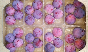
The size of the fruit is about 80 g and the fruit shape is circular. The ground color of the pericarp is yellow, and in marsupial cultivation, the whole color is deep magenta. The flesh is slightly reddish and pale yellow and slightly moist, and the sugar content is about 13 degrees, and the sweetness and sourness are well-balanced and pretty and beautiful.
Plum production area competitiveness enhancement support project (Yamanashi Prefecture support project): With the lifting of the import ban on Prunus salicina Lindl. JA Fuefuki for plum farmers, Yamanashi Prefecture supports. In Yamanashi Prefecture, the import ban on plums produced in the United States was lifted in August 2021, and in order to strengthen the system for stable production of high-quality plums, support for plum producers in the prefecture: National fruit tree management support measures project It is a small-scale replanting of less than 2 a, which is out of scope, and assists in replanting to excellent varieties promoted by the production area. The amount of subsidy is a fixed amount (39,000 yen per 1 a). We are subsidizing the development of rain shelter facilities in plum cultivation fields. The subsidy rate is within 1/2 (with an upper limit), equipment that contributes to stable fruit set (high-performance anther collector, anther opener, pollen mating machine) and equipment that streamlines shipping work (voice type weight sorter). ) Subsidies for expenses related to the introduction. Subsidy rate is within 1/2 (with upper limit)
A variety selected and bred from seedlings obtained by mating "Hatsuhikari plum" with "Mammoth cardinal plum" in Date City, Fukushima Prefecture, in June 1995. The variety was registered.
コメント
コメントを投稿